Wednesday, 14 June 2017

Resolute Qarmartalik School Science Fair


Bad weather in Resolute during late winter.

Bad weather can be frustrating when your excitement to begin summer research is at a high. You have all your personal gear packed. You have spent two days organizing everything you need for the next month.  All of your scientific equipment is ready to be installed. But the weather keeps changing. Snow keeps falling. Visibility is poor. And planes remain grounded. This can be trying. But then an opportunity to visit the community and participate in the science fair at the school is presented to you. You forget about the fact that there are delays in getting to the field and you remember that outreach opportunities like this are one of the reasons we are involved in Arctic research.

For the last four years, the Polar Continental Shelf Program (PCSP), Natural Resources Canada (NRCAN), have sponsored a science fair for Grades 1-11 at the Qarmartalik School in Resolute Bay. This year, students presented their research on which form of renewable energy would have the greatest benefit for Resolute, how to better insulate housing in the community, the best toothpaste to use to protect their teeth, the best compost to use in this environment, and many other topics that the students were either passionate about or that were directly relevant to their day-to-day lives in the Arctic.

Researcher Neal Scott with several students at the Qarmartalik School Science Fair.  NRCat was also on hand for the festivities! [picture posted with permission of parents and school]

We were fortunate enough to be invited to judge this year’s science fair along with other community members (e.g., the RCMP) and encourage the students’ scientific curiosities. This opportunity also enabled us to meet and talk with the parents and teachers of this remote community. We were shown traditional tools used to clean and stretch animal hides. We were each given syllabic charts to encourage us to learn how to write our names in Inuktitut, and we were taught a traditional game, where the goal is to be the first person to get the end of their stick into one of the small holes drilled into a caribou antler. But for the children (and ourselves if we are being honest), the best part of the day was a visit from the Natural Resources Cat (NRCat) – for which it didn’t take long for the kids to “de-tail” the costume (3 minutes to be exact).  

It was a great day to share the excitement of science with the children of Resolute!

Sunday, 12 February 2017

Polar Continental Shelf Program

We are working hard to get ready for our 2017 field season at CBAWO. There is a lot to organize- people, schedules, equipment, flights, and funding.  It is a job that seems to start about a month after we return from the field and continues for most of the year- and in reality it is just that. There is a lot of work in the background that makes research at CBAWO and other projects across the Canadian Arctic possible.

Based in Resolute, Nunavut, PCSP is a logistics support agency that makes Arctic research possible.  

One group that deserves a lot of credit for our research success is the Polar Continental Shelf Project (PCSP).  This small program is part of Natural Resources Canada, the national government, and has been operating in the the Arctic since 1958.  It is probably not an overstatement to suggest that PCSP has supported almost every major research project in the High Arctic over the years, involving thousands of researchers. Many of the projects are based in Resolute or other communities in the Arctic, but a large number of them are like ours, located in remote field camps scattered over an area the size of western Europe.  PCSP has been a bedrock support for all of this research, by providing logistics, aircraft, vehicles, field equipment, and a base of operations in Resolute where they can seemingly help you with any problem.  They also have a well-earned reputation for serving great food in their cafeteria and there is nothing like cleaning up with a hot shower and reconnecting with the world after a long field season at the PCSP base.

PCSP facilities have changed quite a bit over the years but the core of the operation is an accommodation building and a warehouse where equipment is stored and maintained.  The accommodation building has expanded over the years, most recently in 2011 when a joint effort with the Canadian Military resulted in a significant expansion.  This collaboration means that military training operations have a home in the High Arctic, and researchers can use the facilities at other times.   They can hold and feed over 200 people, and when the weather is bad and flights are not moving, they can find themselves with a full house!

The PCSP accommodation and lab buildings in mid-May.  Staff have been working since January with researchers and military training exercises.

The PCSP warehouse is a huge building filled with field equipment. There is seemingly everything there:  tents, drills, boats, snow machines, radios, and every kind of camping gear.  There is a full mechanics shop for keeping everything thing running smoothly and those "can you help me with this?" moments. They have a supply of fuel for everything, all planned the year before and brought up on the sealift in September.  Upstairs there are storage spaces for us to leave equipment over winter, which saves a tremendous amount of freight expense for researchers.

Putting it together in the warehouse.  A load arranged to fly out to the field camp with everything you need to survive and do science.

Perhaps the most important aspect of PCSP is the access to charter aircraft they facilitate and support.  Small planes like the Twin Otter in the picture below are the workhorses of the Arctic, able to land on almost any surface and move equipment and people to the most remote parts of the Arctic. PCSP usually has 1-2 of these aircraft on contract, as well as helicopters and even larger planes when the need arises.  Aside from facilitating the use of the aircraft for researchers, PCSP Base Managers work to make the most of these planes. That often means arranging sharing of flights and using unused return flights for other purposes.  This is no small task to manage, and when the meter is running at about $2500 each hour, this effort is really critical to stretch research budgets. The process of dispatching flights is complicated and will be the subject of another post, but suffice to say it is something that the research community that PCSP serves is really dependent on!

Waiting for the next trip- a Twin Otter at the PCSP base in Resolute.
There are many other partners that make our research possible, but there are few that seem to do as much with so little as PCSP. They are really one of Canada's great successes that more people should know about.  When the rest of the world plans to develop their polar research support, they have come to PCSP to learn how to do it.

Wednesday, 1 February 2017

Lake ice cover time lapse

Have you ever wondered how ice melts on an Arctic lake?  We have time lapse cameras that take images every 30 minutes of each lake.  When we combine them into videos, you can watch the ice come off in a few minutes.

Sit back and enjoy the 2012 ice-off on East Lake!


Monday, 16 January 2017

QUAWLity- a new laboratory for research at Cape Bounty


As the research program has become more complex at Cape Bounty, we have needed increasingly sophisticated laboratory facilities and increased amounts of power in the lab.  This is not a trivial issue in a remote camp.  In the past we have made due with temporary lab tents and used a portable generator, but these conditions were less than ideal and the generators were noisy, need gasoline and ultimately can be unreliable.  This is the story of how we built our new lab facility, QUAWLity (Queen's University Arctic Watershed Laboratory).

With support from the Canadian Government Natural Sciences and Engineering Research Council (NSERC), QUAWLity moved from the drawing board to reality.  We shipped up the Weather Haven tent and arranged wood for the floor from a supplier in Resolute.  It all arrived in camp in early August 2015 and construction began.

The floor was first to be built.  We are not allowed to put in permanent foundations, so we placed the wooden floor on blocks and built it with insulation and linoleum to make it cleaner and warmer.


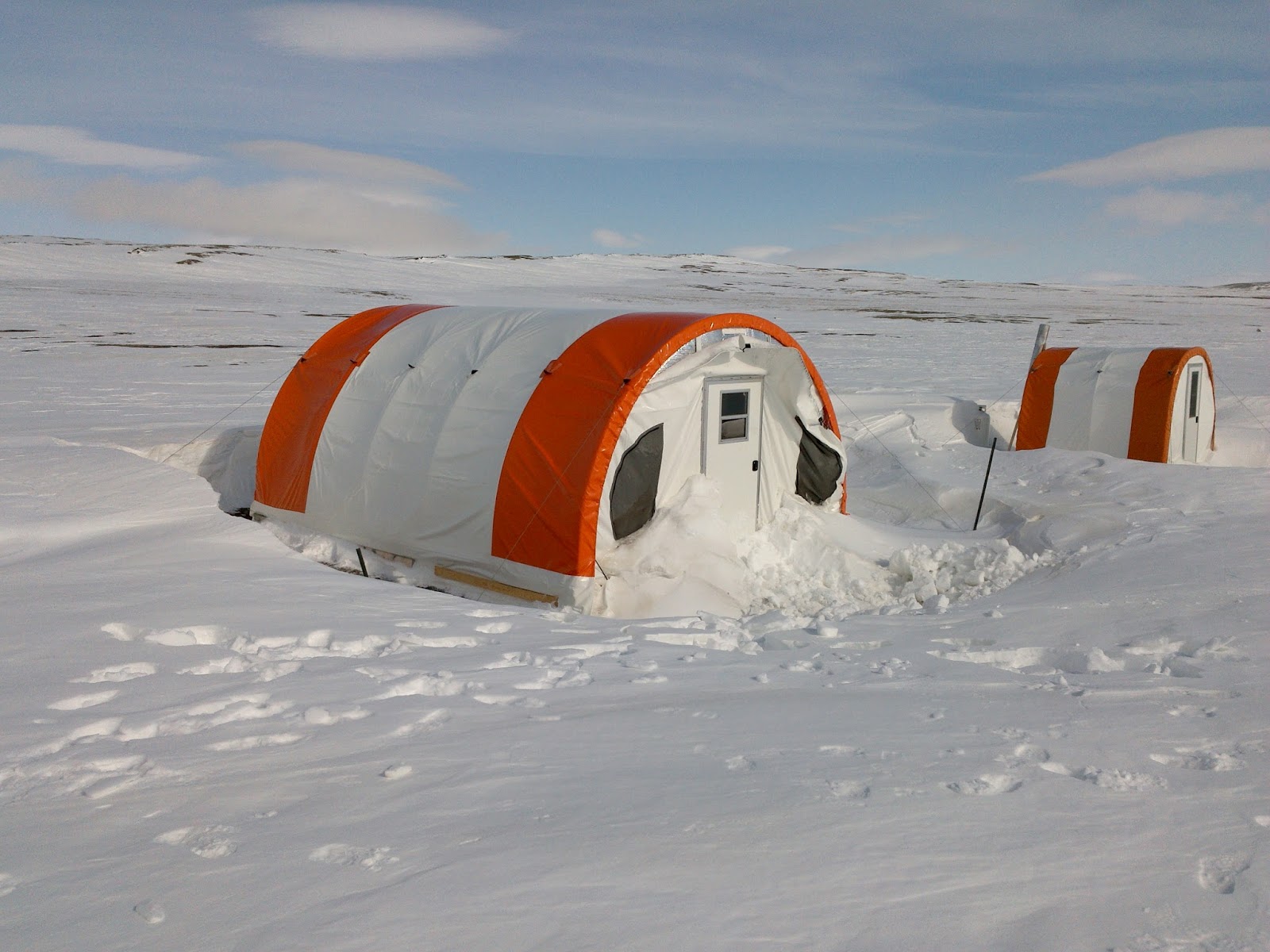
It was a group effort to build the tent.  Conditions were calm and foggy, perfect for handling the large tent pieces.  These tents are very well designed and have robust metal frames and vinyl covers that are suitable for long term exposure.  The tent went up quickly despite the dreary weather.


The construction crew, just before cutting the front door out.


The finished tent, secured to the ground with long metal stakes and metal guy wires.


That was it for 2015, we left the tent empty until 2016.  Arriving in May, you never quite know what to expect, but other than a bit of loose material at the front, all well well.  These tents create large snow drifts, but the upwind side is usually bare of snow.


The first order of business was installing the propane wall furnace.  Dr. Benjamin Amann was eager to help!


We organized the lab into a series of workstations where sample filtering and handling could be carried out. The fume hood was a nice addition that allows safe handling of acids needed to stabilize some samples and a propane chest freezer means no more running the generator to keep the cooler frozen.


The last part of the set up was a solar system. Inside the tent are a panel for the electronics and a cooler for the AGM deep cycle batteries.  These batteries are designed not to freeze so they are safe to use in this setting and the cooler provides further protection from temperature extremes.  A temperature logger placed with the batteries showed that they stayed at -30degC or warmer, compared to almost -50degC outside at times.  They were fully charged when we arrived in mid-May


The 300W of solar panels are on a wooden frame outside, secured down with guy wires.  The orientation is perfect to have the wind scour the panels and keep them clear of snow in the winter. Even though we have 24-hour daylight during field seasons, the midnight sun does not charge our batteries!


After a full season in 2016, everything seems to be running well.  The lab tent is a clean, warm and spacious place to do our work and we really pushed it with a large field crew in 2016.  Everything worked to expectations, and the roller chairs really make life easier.  The solar system was sufficient to power everything so we are now officially free of generators for the lab.  It's all part of doing research 400 km from the nearest community in the remote High Arctic.

Monday, 2 January 2017

Biogeochemical Research in the High Arctic

Hi! My name is Gillian and I’m a first-year Master’s student at Queen’s. Dr. Melissa Lafrenière, co-manager of the Queen’s Facility for Biogeochemical Research on Environmental Change and the Cryosphere (FABRECC: http://www.queensu.ca/geographyandplanning/fabrecc-lafreniere/home) is my supervisor. We are working to better understand biogeochemical processes at the Cape Bounty Arctic Watershed Observatory. In other words, we study the interactions between the physical, chemical, biological, and geological processes occurring in the High Arctic permafrost environment.
               
Specifically, I study carbon in organic matter. The permafrost of the Arctic stores huge amounts of organic carbon. In fact, researchers estimate that there is twice as much carbon stored in the permafrost as there is carbon in the atmosphere right now. As permafrost degrades due to warming temperatures, some of the permafrost carbon could be released to the atmosphere as greenhouse gases such as carbon dioxide and methane.

Why will only some of the carbon be released? Well, only a portion of the permafrost carbon is decomposable, and carbon must undergo decomposition to produce greenhouse gases. My job is to determine what makes the carbon decomposable and identify where the decomposable carbon is likely to be found on a High Arctic landscape.

Knowing how much carbon is decomposable, and where it’s located, is important for developing climate models. Because data on decomposable carbon are limited, carbon stored in permafrost isn’t well incorporated into current climate models. The results of our research could change that. For example, if we know there is a lot of decomposable carbon stored in areas highly susceptible to enhanced permafrost thaw, then we might conclude there is a high probability of greenhouse gas emissions in those areas. This increased probability can then be accounted for in climate model projections, making them more accurate.

A soil profile at one of my sampling sites at the Cape Bounty Arctic Watershed Observatory on Melville Island, NU.

I collected soil and water samples from sites with varying geomorphology and vegetation at Cape Bounty during the summer of 2016. Back in the lab at Queen’s, I incubated these samples for twenty-eight days. During an incubation, the samples were kept a constant temperature. At specific time points throughout the incubation period, I removed a subset (or aliquot) of each sample and analyzed it to characterize the molecular structure of its carbon compounds and its organic carbon concentration.

Now that the incubation period is finished, I can calculate how much organic carbon was lost (through decomposition) over the twenty-eight days. Better yet, I can compare these data with the molecular structure of the carbon compounds to see if molecular structure is an indicator of decomposability. If they are related, it would be really exciting since the methods used to characterize molecular structure are much easier to perform than the incubations. If molecular structures could be used to predict carbon decomposability instead of incubations, it would save researchers a lot of time and money!
An emission excitation matrix (EEM), like the one shown above, provides insight into the molecular structure of carbon compounds in water samples.
The next step for my project will be to look at how the decomposability of carbon varies by sample site. If we identify a relationship between carbon decomposability and study site characteristics, we could use this to predict how carbon decomposability will vary across the broader landscape. For example, if we find that carbon decomposability is related to a certain vegetation community, we could use vegetation cover maps to predict how carbon decomposability varies across the landscape.

               
The best part about my project is that I get to go back to Cape Bounty next summer for a second field season. So, based on what I find out from the lab work I’m doing now, I can tailor my 2017 sampling plan to better address my research questions. Stay tuned for more results and stories about field season preparations later this winter! 

Sunday, 11 December 2016

Imaging (and imagining) High Arctic Lakes

Guest post by Alexandre Normandeau

Maps of the lakes showing the detailed bottom bathymetry.  Blue and purple colours are the deepest areas.  
High Arctic Lakes are commonly used for environmental reconstructions because they are particularly sensitive to climate change. The Cape Bounty Arctic Watershed Observatory is probably one of the best examples of research sites that has shown the effect of climate change on landscape disturbances. The study of lake sediments can also provide information on natural hazards such as earthquakes and extreme flood events.  Ice cover is so pervasive on these lakes that it sometimes takes many years for conditions to occur that allow us to look into the lakes with modern research equipment.  After trying two previous years, in August 2015 we were finally able to finish surveying the lakes.

To analyze in great detail the history of natural hazards and climate change in the region, we brought very high-resolution echosounders in the High Arctic to map the bottom of the Cape Bounty’s lakes. These instruments emit soundwaves that travel to the bottom of the lake, and are reflected from the lakefloor before being recorded back by the echosounder. While commonly used echosounders are singlebeam (e.g., fishing echosounders), we use multibeam echosounders. This allows us to "see" on a 150° angle on each side of the boat, providing a complete image of the lake floor, similar to what Google Earth does for the land. These instruments are typically used on large research vessels and in accessible locations (near a road or human infrastructures). It was thus quite a challenge to bring our scientific equipment to such a remote location that is Cape Bounty. In collaboration with Université Laval, instead of using a large research vessel, we managed to fit our echosounder on a 7.5 m long zodiac. It is the first time that such an high-resolution mapping of lake floors is accomplished in the High Arctic.

Matt Gillman (M.Sc. student) on the Zodiac with the echosounders used in the High Arctic.


The data collected during the summer of 2015 was then corrected for vessel motion, lake-level fluctuations, sound refraction into the water, etc. The processed image of the lake-floor (Fig. 2) allowed us to understand sedimentary processes related to climate change (sea-level fluctuations, glaciations) and natural hazards (mass movements, floods).


Monday, 28 November 2016

Life at Cape Bounty

Guest post by M.Sc. student Amanda Schevers

The best way to carry the stand for the precipitation collectors. This is at the top of the West River catchment, I’m just about to install the final collector. 

I never thought I would ever consider battling snowstorms, bone-chilling winds, and sub-zero temperatures for an entire summer to be so rewarding and fun, yet somehow I ended up at Cape Bounty. Despite hearing stories from past students, seeing pictures, and reading more papers than I can remember, I still managed to be completely shocked when I hopped off the plane onto the lake ice. No pictures will ever do this place justice.
            But why am I here, in an uninhabited island in the middle of the High Arctic? Sometimes, when I get caught up in the small details of things, stepping back and re-reading my research proposal helps remind me what I am actually trying to accomplish while I am here (which, by the way is for a total of 64 days). We’ve heard all about climate change and how much it will change the world we live in, but how exactly is it going to change the surface water we, and countless aquatic ecosystems rely on?
To help answer this question, I’m going to be monitoring two rivers and their respective watersheds. This may sound easy, but it means I’m going to end up hiking 15-20 km carrying 10-12 litres of water every single day. Luckily I have PhD candidate Casey to help me out. We installed a network of monitoring stations, wells to collect subsurface water, and four precipitation collectors across the landscape. My first week at camp was spent out on the tundra, getting to know the land, the equipment, and getting a taste of the wide range of research that occurs at Cape Bounty.
            One of the best parts of hiking such a large area every day is the chance to see so many incredible things. Hiking up through snow lined channels, stopping to admire the approaching wolves, caribou, and muskox, and checking out all the bones scattered across the tundra are some of my favourites.

Before installing stations, we decided to walk up the East river channel. Water creates some pretty cool features. 


            Life at camp hasn’t been too shabby either. We’ve managed to bake a giant cookie, brownie, and apple crisp all in a frying pan. After a long, cold day in the field and in the lab a relaxing evening with dessert and camp stories are the perfect way to end the day.