Showing posts with label Camp. Show all posts

Monday, 16 January 2017

QUAWLity- a new laboratory for research at Cape Bounty


As the research program has become more complex at Cape Bounty, we have needed increasingly sophisticated laboratory facilities and increased amounts of power in the lab.  This is not a trivial issue in a remote camp.  In the past we have made due with temporary lab tents and used a portable generator, but these conditions were less than ideal and the generators were noisy, need gasoline and ultimately can be unreliable.  This is the story of how we built our new lab facility, QUAWLity (Queen's University Arctic Watershed Laboratory).

With support from the Canadian Government Natural Sciences and Engineering Research Council (NSERC), QUAWLity moved from the drawing board to reality.  We shipped up the Weather Haven tent and arranged wood for the floor from a supplier in Resolute.  It all arrived in camp in early August 2015 and construction began.

The floor was first to be built.  We are not allowed to put in permanent foundations, so we placed the wooden floor on blocks and built it with insulation and linoleum to make it cleaner and warmer.


It was a group effort to build the tent.  Conditions were calm and foggy, perfect for handling the large tent pieces.  These tents are very well designed and have robust metal frames and vinyl covers that are suitable for long term exposure.  The tent went up quickly despite the dreary weather.


The construction crew, just before cutting the front door out.


The finished tent, secured to the ground with long metal stakes and metal guy wires.


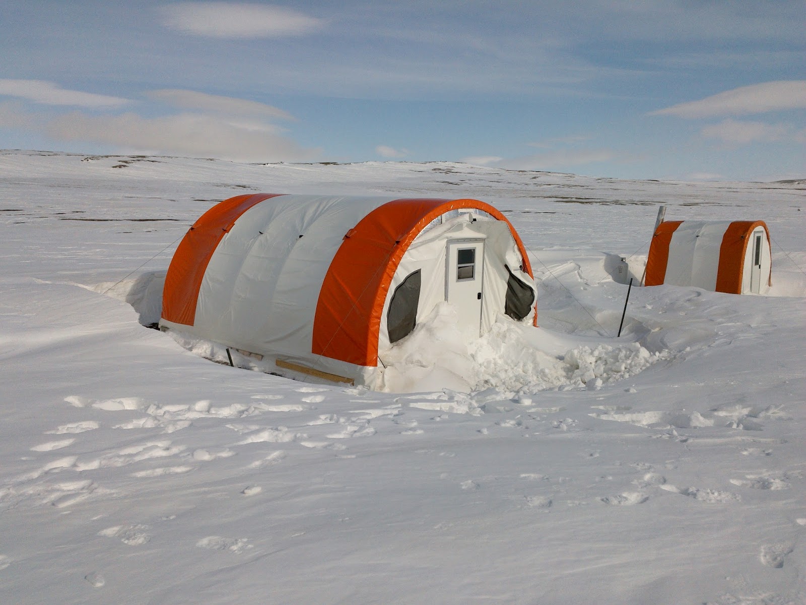
That was it for 2015, we left the tent empty until 2016.  Arriving in May, you never quite know what to expect, but other than a bit of loose material at the front, all well well.  These tents create large snow drifts, but the upwind side is usually bare of snow.

The first order of business was installing the propane wall furnace.  Dr. Benjamin Amann was eager to help!


We organized the lab into a series of workstations where sample filtering and handling could be carried out. The fume hood was a nice addition that allows safe handling of acids needed to stabilize some samples and a propane chest freezer means no more running the generator to keep the cooler frozen.


The last part of the set up was a solar system. Inside the tent are a panel for the electronics and a cooler for the AGM deep cycle batteries.  These batteries are designed not to freeze so they are safe to use in this setting and the cooler provides further protection from temperature extremes.  A temperature logger placed with the batteries showed that they stayed at -30degC or warmer, compared to almost -50degC outside at times.  They were fully charged when we arrived in mid-May


The 300W of solar panels are on a wooden frame outside, secured down with guy wires.  The orientation is perfect to have the wind scour the panels and keep them clear of snow in the winter. Even though we have 24-hour daylight during field seasons, the midnight sun does not charge our batteries!


After a full season in 2016, everything seems to be running well.  The lab tent is a clean, warm and spacious place to do our work and we really pushed it with a large field crew in 2016.  Everything worked to expectations, and the roller chairs really make life easier.  The solar system was sufficient to power everything so we are now officially free of generators for the lab.  It's all part of doing research 400 km from the nearest community in the remote High Arctic.

Monday, 28 November 2016

Life at Cape Bounty

Guest post by M.Sc. student Amanda Schevers

The best way to carry the stand for the precipitation collectors. This is at the top of the West River catchment, I’m just about to install the final collector. 

I never thought I would ever consider battling snowstorms, bone-chilling winds, and sub-zero temperatures for an entire summer to be so rewarding and fun, yet somehow I ended up at Cape Bounty. Despite hearing stories from past students, seeing pictures, and reading more papers than I can remember, I still managed to be completely shocked when I hopped off the plane onto the lake ice. No pictures will ever do this place justice.
            But why am I here, in an uninhabited island in the middle of the High Arctic? Sometimes, when I get caught up in the small details of things, stepping back and re-reading my research proposal helps remind me what I am actually trying to accomplish while I am here (which, by the way is for a total of 64 days). We’ve heard all about climate change and how much it will change the world we live in, but how exactly is it going to change the surface water we, and countless aquatic ecosystems rely on?
To help answer this question, I’m going to be monitoring two rivers and their respective watersheds. This may sound easy, but it means I’m going to end up hiking 15-20 km carrying 10-12 litres of water every single day. Luckily I have PhD candidate Casey to help me out. We installed a network of monitoring stations, wells to collect subsurface water, and four precipitation collectors across the landscape. My first week at camp was spent out on the tundra, getting to know the land, the equipment, and getting a taste of the wide range of research that occurs at Cape Bounty.
            One of the best parts of hiking such a large area every day is the chance to see so many incredible things. Hiking up through snow lined channels, stopping to admire the approaching wolves, caribou, and muskox, and checking out all the bones scattered across the tundra are some of my favourites.

Before installing stations, we decided to walk up the East river channel. Water creates some pretty cool features. 


            Life at camp hasn’t been too shabby either. We’ve managed to bake a giant cookie, brownie, and apple crisp all in a frying pan. After a long, cold day in the field and in the lab a relaxing evening with dessert and camp stories are the perfect way to end the day. 

Tuesday, 6 September 2016

Day in the Life of an Arctic Scientist

(Contributed by CBAWO student Maddie Harasyn- Queen's University)

Science in the Arctic has turned out to be really fun! I have been here for just over two weeks and I’m actually starting to get used to the Cape Bounty routine. It usually begins with waking up at 7:30 AM to the bright light shining through the fluorescent walls of the tents we all sleep in. Then the whole crew migrates down to the Weatherhaven (what we call our mess tent) for coffee and a breakfast of either oatmeal or pancakes. We typically add excessive amounts of toppings to our breakfast to change it up a little – peanut butter, Nutella, raisins or on special mornings M&M’s. Over breakfast, we talk about all of our schedules for the day.

My schedule involves walking down to the river beside our campsite at 9 AM and collecting water samples. I then filter the water samples to measure the amount of suspended sediment, dissolved oxygen and ions in the water which involves three separate filtering processes. Often other researchers in camp offer to help me filter, as we all help out each other when we can! I then hike out to the three smaller sub-catchments that feed the river which I just sampled and collect the same water samples at each, which is about an hour and a half hike. We always go out in pairs for safety, so the hike is filled with good conversation and lots of laughs. We often find cool things on our hikes as well, like interesting rocks or full skeletons of Muskox.

Then back to filtering in our lab tent, which occupies time until lunch rolls around. For lunch, we often make soup, Kraft Dinner or eat copious amounts of peanut butter and jam on Ryvita crackers. My afternoon often consists of helping others with their research projects – like installing sensors, or hiking up to one of the sub-catchments to collect data from the loggers recording data across the landscape. It is very interesting to learn what other students are studying up here, and how their projects are coming along. Everyone has very interesting and very diverse topics, which makes every day different and exciting. To end off the day, I complete my final rounds of water sample collections at all of the sites, and filter everything before dinner. Some dinner favorites are spaghetti, burritos or chili. Over dinner, we chat about what we accomplished during the day and neat things that we all found out on the tundra. Then we head back off to bed, in the same brightness which we woke up to.


Hiking to East Lake to collect water samples.


My personal project is looking at the water chemistry in the East and West Lake to the south of our campsite. A previous researcher discovered that small depressions exist in the bottom of the lakes, which could hint that groundwater is seeping into the lakes via these sites. My project is focused on determining the source of these depressions, which I will do by studying the water chemistry in each depression. This is done by drilling holes in the lake ice, and lowering a device down the water column slowly that measures depth, electrical conductivity, temperature, dissolved oxygen and turbidity. Water chemistry samples are also collected at the bottom of each site, to be analyzed for ions and isotopes back in the lab. After lowering this device at all 22 sites, the data can be viewed on one of the lab computers and studied to help hypothesize what may be occurring at the bottom of the lake at these sites.


So far, I have found that the East Lake has mostly uniform conductivity throughout the water columns at all of the sites, whereas some specific sites in the West Lake show an increase in conductivity and decrease in dissolved oxygen with depth in the lower water column. This could suggest that groundwater is entering the lakes through these depressions, as groundwater would have a higher concentration of dissolved ions which increase the conductivity of the water at these sites. The water chemistry analyses and historic records of the disturbance patterns in this area will help consolidate this hypothesis, which will be completed as part of my thesis back at Queen’s throughout the final year of my undergraduate program.

Both lakes we are studying can be seen above: East to the left and West to the right.

Monday, 13 June 2016

2016 Reseach season: snow, soil and ice

This blog has been quiet for two years- hard to believe how fast the time went by.   We'll try to post more frequently, especially now that the field season is underway.

We opened the camp on May 18 and found the tents and equipment in generally good shape.   Conditions were already looking unusually warm based on weather from other stations in the area, and a pilot mentioned that he saw little snow on Melville Island while flying over in March.  


When we arrived, there seemed to be a lot of snow, especially around camp where we had to dig it out.  However, when we did our snow survey, we found it was quite the opposite.  Snow is a funny thing, you just can't measure it in one spot.  It blows around all winter and the depth tends to be quite different from place to place.  Each year we carry out a snow survey that involves 28 locations in the river basins and at each location, we measure depth in ten spots along a line.  We also collect snow samples with a metal tube and weigh the snow to determine how much water there actually is in the snow.  This gives us a way to calculate what hydrologists call the "snow water equivalence", or SWE (s-whee).  One way to think of SWE is how much water would be left on the land if you melted all of the snow.  It is measured as a depth, so you can think of the depth of water for a given SWE.  

The snow at CBAWO this year was very limited, the least we have measured since 2005.  It was 49 mm, about 60% of a typical year.  In many places, the snow was just a thin covering over the soil.  That indicates that there is very little water on the land for runoff this spring, something that is very important for many of the systems we monitor.

One of the things that we were interested in sampling this year was the frozen soil to see how much water was in it and how ice was formed the previous winter.  This affects how the soil thaws and how the water will flow in the soil.  Many researchers recover samples of the deeper permafrost, but this soil is not really permafrost, as it almost always thaws.  We refer to this as the "active layer", or the part of the soil that thaws during the summer.  As the name implies, this is the part of the soil where a lot of important things happen:  plants root, water moves and changes properties, and an important ecosystem of microbial life recycles dead plant matter and supports vegetation growth.  

To sample the frozen soil, we use a power auger and a hollow bit that cuts down and brings up frozen soil material.  The auger is big, powerful, and has a mind of it's own:  when it hits a rock, it can stop dead and throw the people operating it.  We give it a lot a respect and have affectionately named it 'Taz', after the Tasmanian Devil in the cartoons!

The frozen soil is pretty neat to look at.  This photo shows a section from 60-75 cm depth, and you can see some clear ice lenses and structure starting to appear.   Ice formed in these lenses late in the autumn and will only thaw late this coming summer.  When it does, the water released will be able to drain out, but we find the quality of this water is very different from snow runoff.  As you go deeper, there is even more ice, sometimes just ice for intervals of 10 cm or more.  


These samples will be analysed for their water content and we plan to get images of the ice structure while they are frozen using a special scanner like the ones they use in hospitals to image bones.  We hope by understanding how water is stored and moves through the soil at different times of year, we can better predict how climate changes will affect water in the High Arctic, and how this will contribute to the stability of the landscape and ecosystem.

And now to tease with an image that looks like something out of a movie.  No, it is not some futuristic weapon.  We actually put that underwater in the lakes to learn more about what is going on at the bottom.  That is a story for another time.  Thanks for following.


Thursday, 31 October 2013

The old camp 2003-2010

The original camp at Cape Bounty was on a low ridge overlooking the West Lake.  We chose the site in May 2003 because it was free of snow in the spring, and the rock surface was very durable and relatively flat.   It was a good site with a great view, and it was close to most sampling locations, which is important when you are doing it every day for 6-8 weeks.  Even after seven years of foot traffic, the site looks untouched.

The problems though, started to mount as our research group grew.  Drinking water became scarce in some years in late July as the land dried up, and moving equipment to the airstrip down at the lake (on the far left of this picture) required an ATV or a lot of heavy hauling. Finally, the wind was much worse at this location than elsewhere. It all came to a head in August 2010 when the main tent was blown down the hill in a severe wind storm.  The tent, salvaged from an old mining exploration camp, was destroyed, and we decided it was time to move the camp.

This photograph was taken in June 2007 in the late evening (around midnight) from "latrine hill".  No one will miss having to slog up the hill for privacy, or to suffer in the wind when the weather was poor. Still, it was quite a view when the weather cooperated!


Friday, 11 October 2013

Camp- our home away from home

In 2011 we moved the camp from the hill north of the West Lake to a site at the air strip closer to the lake.  It is much better location that makes moving equipment in the summer possible without vehicles, and it is much smoother for sleeping on the ground.  Another important benefit is the close proximity of the lake and river for drinking water later in the season.  It is definitely less windy!

The camp is composed of a main Weather haven tent for cooking and meeting, and a smaller Weather haven tent for the latrine.  Moving to this location close to water meant that we had to install a propane-fired incinerating toilet.  It is not nearly as awful as it sounds!

We also set up temporary sleeping tents for each person about 200 m from camp.  You can see the "field' of the yellow tents on the left.


 Flights into CBAWO are either with ski- or wheel-equipped Twin Otters.  The lake ice provides a good landing site for the ski planes until early June.  The summer strip is marked on the tundra with white bags filled with rocks and is aligned with the prevailing northwest winds.  It looks quite soft, but it is actually river gravel with a soft moss cover, so the wheels of the plane compress it but do not sink in.  You can see in the foreground where we have had to fill in a frost wedge with gravel.  Each year, the wedges are settling more and this needs to be dealt with.


We leave the Weather haven tents up over winter and remove all food and cooking equipment from the site to avoid attracting animals.  Of course, the tracks and scat suggest we get frequent winter visitors.

It does not snow much in the High Arctic.  There is usually 20-40 cm of snow on the land, but it gets blown around and drifts extensively.  In the spring, our tents have caused massive snow drifts.  Thankfully, digging out was not too much of an issue, as long as we remember where everything is.  For this reason, we photograph the site before leaving in the summer, and we keep important things like tools, shovels and some fuel inside the main tent so it is easy to find.